This vintage pamphlet from 1975 Geology and Man was the official guide to Geology Tour Road in Joshua Tree National Monument (now a National Park). It was written by Elden K. Wanrow a park naturalist.

Keep America Beautiful For Its 200th Birthday 1776-1976
It is Dangerous to Travel off the Established Roads
U.S. DEPARTMENT OF THE INTERIOR
As the Nation’s principal conservation agency, the Department of the Interior has basic responsibilities for water, fish, wildlife, mineral, land, park, and recreational resources. Indian and Territorial affairs are other major concerns of America’s “Department of Natural Resources” The Department works to assure the wisest choice in managing all our resources so each will make its full contribution to a better United States – now and in the future.
NATIONAL PARK SERVICE
Joshua Tree National Monument is one of the areas administered by the National Park Service, a bureau of the Department of the Interior. The wildlife, plantlife, and all other natural features are preserved here for your pleasure and for the enjoyment of the many visitors who will follow you in the years ahead. You can help to preserve the beauty of our parks by taking away only pictures and pleasant memories, and leaving behind nothing except possibly your own footprints.
This guidebook is Published by the JOSHUA TREE NATURAL HISTORY ASSOCIATION
a non-profit organization pledged to aid in the preservation and interpretation of the scenic and scientific features of the Monument.
Produced in cooperation with the National Park Service
JOSHUA TREE NATIONAL MONUMENT
Twentynine Palms, California 92277

This is your guide through some of the most fascinating landscape in Joshua Tree National Monument.
The Numbers appearing the left margin correspond with numbered markers along the tour route.
Mileage starts at the intersection of the Geology Tour Road and the main Monument road. The 16 Stops along the 18-mile tour will require approximately two hours and will return you to this point.
Please help us protect and maintain this natural environment so that others may benefit from it as you have.
GEOLOGY AND THE MONUMENT. The face of the earth is not fixed or unchanging, but represents only a fleeting phase of a very long history. Significant changes are now going on all around us and we are able to understand present-day aspects of the earth only by a knowledge of the changes in the past.
The science which deals with these changes is called geology. More precisely, geology may be defined as the study of the history of the earth as revealed in the rocks and sediments.
This tour will aid you in understanding the desert landscape and forces which have created it, thereby strengthening your appreciation of the natural environment.
The area encompassed by Joshua Tree National Monument has been restless for than 800 million years. Geologic maps of California indicate that perhaps as many as ten different times the Monument area sank below sea level and was covered by marine water. Things as they stand today are the result of erratic uplifting of the surface rock; its subsequent erosion now exposes much of the younger rock which had pushed its way up into the older rock types. We therefore have the opportunity to see very old rocks, intruded by younger ones. All of these have been subsequently fractured and jointed by regional crustal disturbances resulting in the earthquakes so often felt in southern California.
1) 0.4 Mi. WHY A VALLEY.
Mountain-rimmed Queen Valley (elevation 4,450 feet) is one of two types of valleys to be found along the tour. This and Lost Horse Valley (to the west) are formed by a difference the the rate of erosion between the rock underlying the valley itself and the rock composing the surrounding mountains.
The rock making up those areas which are now valleys itself is generally less resistant to erosion than the rock forming the surrounding mountain and disintegrates sooner to form a low-lying plain (or “valley”).
Pleasant Valley, seen later on the tour, is the result of faulting and consequent uplift and subsidence.

2) 0.8 Mi. A RAIN DROP DIVIDES.
It is interesting to note here on this knoll is the north-south drainage divide for the Monument. One would normally expect such a divide to occur on the crest of one of the mountain ranges to the north or south. Actually, water drains from this point either to the northwest via Quail Springs Wash, or to the southeast via Fried Liver Wash into Pinto Basin. The power of running water plays an important part in shaping the desert landscape.
3) 1.7 Mi. NATURE’S GUTTER.
Here, where run-off water accumulates to from a wash, we can see the effect of water in the desert. During the summer months, intense rainstorms often produce flash flooding along many desert washes. Rocks are physically and chemically broken down by the flowing water. The loosened material is carried to lower elevations by the flowing water and deposited. These deposits, called alluvial fans, will be seen later on the tour.
The increased soil moisture along these washes allows certain plants, such as the California juniper and the Parry nolina, to grow here more readily then on the drier surrounding desert.
4) 0.3 Mi. OLD EROSIONAL LEVEL.
Many of the quartz monzonite boulders to the left (east) of the road bear a distinct groove or band about seven feet above ground level. Geologists believe that this indicated an old erosional level during which the soil surface remained at one point fro some time; perhaps, however, it indicates a more moist prehistoric climate during which time more water was available at ground level and the force of blowing sand eroded the rock more deeply at that point to produce the grooves. Subsequent erosion has lowered the soil to its present level. This illustrates how changes in climate produce corresponding changes in the landscape.
5) 0.5 Mi. ROCK PILES
The quartz monzonite, forming the rock piles on both sides of the road, was once part of a molten mass which was forced upward into the overlaying, older Pinto gneiss (pronounced “nice”) rock. The monzonite cooled without reaching the surface and crystallized to from solid rock. Erosion over the ages has stripped away the darker Pinto gneiss, exposing the monzonite outcrops as you see them. The mountains to the right (west) are composed primarily of gneiss, and Ryan Mountain, near Cap Rock, displays the contact between the two kinds of rock. Harder, more resistent areas within the monzonite from the numerous rock piles. Many of these have well-defined joint systems, while others have collapsed and are nothing more than jumbled piles of rock.
6) 0.6 Mi. ROCK SCULPTURE
The monzonite was fractured into many cracks and joints, usually to sets intersecting at nearly right angles. The agents of erosion are best able to attack the rock along these zones of weakness and weathering occurs at a faster rate. The result is boulders which are roughly rectangular in shape. A massive rectangular boulder to the left of the road illustrates this type of erosion. Many of these boulders weather into grotesque shapes and have been given such descriptive names as the “Skull” (found near Jumbo Rocks) and the “Trojan” and “The Ox” (found along the Hidden Valley Nature Trail).

7) 0.5 Mi. MALAPAI HILL
Three-quarters of a mile west of this point the twin peaks of Malapai Hill rise about 400 feet above the valley floor. The hill is composed largely of black basalt and apparently resulted from a shallow injection of molten or liquid material which did not quite reach the surface of the earth. If it had reached the surface , a lava flow or volcano would have resulted, but no such floe exists. The basalt intrudes the quarts monzonire and is probably quite young, though its true age is unknown. It could have formed within the last two or three million years, which is quite recent compared to the gneiss, which is over 700 million years old.
If your time permits, take a short stroll to the base of Malapai Hill for a closer look. A balanced rock occurs about 1/4-mile west of here, about halfway to the hill.
8) 0.4 Mi. ALLUVIAL FANS
You are now descending an alluvial fan. Notice a similar fan extending from the mountains into the valley directly in front of you. These fans are composed of sand, gravel and rock produced from the erosion of rocks at higher elevations. This material is carried by gravity and flood waters to lower levels. Here it is deposited, the larger, heavier rocks being dropped first, and the lighter sands and gravels being carried farther out into the valley. The alluvial fans illustrate the constant change that is taking place. Mountains are being destroyed and the material is being deposited. Some might be consolidated into rock which could thrust up as new mountains.

9) 0.4 Mi. SQUAW TANK
At this point in our tour, man enters the scene and we can see evidence of how his natural environment has been used to good advantage. Achaeological investigations tell us that nomadic Indians inhabited this area from about 1000 A.D. until the turn of the century. Squaw Tank was a favorite campsite for them. Bowl-like mortars were hollowed into flat surfaces of the quartz monzonite and were used to grind seeds and other bits of food into meal. Several of these bedrock mortars can be seen just south of the large rock in front of you. About 100 feet farther to the southeast, and in the wash, can be seen a concrete dam which forms Squaw Tank. Cattlemen built this and other similar dams to catch runoff water for their cattle during the early 1900’s. Many of these dams are located where “natural tanks” or pools of water collected after rains. It was in such places that the Indians also obtained water.
DIKES
Notice the light-colored bands of rock cutting across many of the monzonite boulders in this area. These bands, called dikes, were formed when molten rock of a different texture intruded into joints in the already-formed monzonite. Many of these dikes are composed of a light-colored, fine-grained rock called aplite. It is much harder and more resistant to erosion then the monzonite, and stands out in relief when the monzonite eroded away from it. An excellent dike, or wall, can be found to the left of the road a short distance beyond this stop.
REMEMBER: STOP HERE IN WET WEATHER
10) 0.2 Mi. PLEASANT VALLEY
As you rounded the point of rocks and viewed the eastern section of Pleasant Valley, the steep mountains in front of and to your left was probably most impressive. This scarp is a result of the Blue Cut fault which has a 50-mile trace stretching from the western foot of the Little San Bernardino Mountains to the eastern edge of the Pinto Basin. The Fault (a zone of weakness 300 to 1000 feet wide) follows the base of the mountain before you. To the left of the fault the land has uplifted, and to the right the terrain has dropped or subsided. This combination of uplifting and lowering has created Pleasant Valley, the second type of valley that you have seen (the first being Queen Valley, a result of differential erosion).
The Blue cut fault is named for the blue material (blue granodiorite) found along the fault zone. The blue exposed on the mountainside to the west (rear) is blue granodiorite and marks the fault.
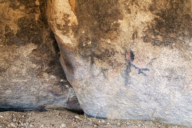
PETROGLYPHS
Petroglyphs or Indian rock carvings can be seen about 150 feet to the left. These are usually found on rocks which have a coating of “desert varnish,” a chemical deposit which forms on many desert rocks. When the outer layer is chipped away, it exposes the light rock beneath. It is thought that these carvings had some religious meaning to the Indians, but the is only conjecture. Many of the carvings may be hundreds or even thousands of years old, because the desert varnish has reformed on some of them and this takes a long period of time. Please help protect this prehistoric Indian art.

11) 1.0 Mi. DRY LAKE
This dry lake or playa you are now crossing is evidence of a wetter climate during which a periodic lake to a depth of hundreds of feet. As the lake dried up, salts in solution were crystallized out and deposited. Many of these dry lakes throughout other parts of the desert are mined commercially for various salts. After heavy rains many of the dry lakes become temporarily “wet” lakes.
SAND DUNES
To the left, notice the sand deposits and the start of sand dune formation. This is typical of areas where there is a source of sand (the dry lake), an open flat area (Pleasant Valley) where wind can gain enough force to pick up sand particles and carry them, and some barrier (the mountain front) which slows the wind so that its load of sand is deposited.
12) 0.4 Mi. MINES
The mountain slopes in front and to your left (north) are honeycombed with tunnels and shafts dug by miners of gold and other precious metals. There was extensive mining activity throughout the area during the late 1800’s and early 1900’s. Very few of the mines were profitable due to limited high-grade ore; the Lost Horse Mine is one of the exceptions. Gold, silver, copper, lead, and other metals of economic importance are believed to be deposited when intruding magma cools and crystallized, and various gasses and liquid solutions rise from the magma. As these move upward through the rock they cool and deposit dissolved material along the way. This deposition usually occurred in preexisting fractures or fissures, resulting in a limited vein of metal. Quartz is often associated with these veins and is an indication of possible valuable deposits.

13) 1.9 Mi. CATTLE RANCHING
Here, along the base of the alluvial fan, where soils are deeper and run-off water accumulates, more plants, especially grasses, are able to survive. Lush vegetation drew cattlemen to the area. Texas longhorns were first brought in during the 1870’s. Over-grazing and continued drought since 1932 led to the decline of the range. The numerous cholla cati in the area indicate an overused range. These replace the grasses as the latter die. The elimination of grazing , with the establishment of the Monument in 1936, has allowed the range to restore itself and only now do we see much evidence of grass.
14) 0.8 Mi. PINTO GNEISS
The Banded and folded rock to your left, probably the oldest type of rock in the Monument, is Pinto gneiss. Although its absolute the is not known, it is thought to be more than 700 million years. Whereas the basalt of Malapai Hill and the quartz monzonite are igneous rocks – the product of a cooled magma – the gneiss is the product of metamorphism. Metamorphism is the change in the structure of rocks due to pressure, heat or chemical action. Geologists believe that the gneiss was originally sedimentary material, laid down in ancient lakes or seas, which has undergone change due to the pressure of overlying material and internal heat. This change results in a realignment of the chemical constituents of the former rock to produce a new rock.
LICHENS
The bright splotches of color found on many of the rocks are primitive forms of plant life called lichens. The different colors indicate different species or kinds. Some form a weak carbonic acid which can chemically break down rock to form soil. These tiny plants form a very important part of the erosional cycle and and are indirectly beneficial to man, who is dependent on the soil for his existence.
15) PINYON WELL JUNCTION
Road to the left is a dead-end road and not part of the Geology Tour. It is not maintained. A Well in this canyon provided water which was necessary for the processing of gold ore and watering cattle. The well is now dry.
16) 0.1 MI. PANORAMIC VIEW
Aside from being an outstanding picture point, this stop affords the opportunity to review at one glance many of the geologic processes seen along the tour. As was pointed out in the introduction, geology is the study of the history of the earth and is manifest by a constant series of changes which involve mountain building, their destruction and subsequent rebuilding. We see evidence of mountain building in the mountain range formed along the Blue Cut fault north of Pleasant Valley. We see mountains formed by igneous intrusion in Malapai Hill and the quartz monzonite rock piles. And finally, we see them being destroyed and carried away to be deposited as alluvial fans or as sand dunes around a dry lake. And throughout, we have seen how man has utilized the products of geology to his advantage.
To return, continue 2.2 miles to Squaw Tank and from there 5.5 miles to the main monument road in Queen Valley. As you approach the Squaw Tank area, notice the mountains to the right (eastward) which have an excellent contact of dark Pinto gneiss and light-colored monzonites.
This is the current NPS guide
California Division of Mines and Geology Geology Tour Road page
Walter Feller’s Digital-Desert Geology Tour Road page